

LIDAR Data
LIDAR (Light Detection and Ranging) is a remote sensing system that determines distance to a surface or object using laser pulses. This system is mostly used to collect topographic data. It works in a similar way to radar technology, where the distance to an object is determined by measuring the time delay between transmission of a pulse and detection of the reflected signal.
Data is collected by mounting a LIDAR laser scanner photogrammetrically in the bottom of an aircraft, along with an Airborne GPS and inertial measuring unit.
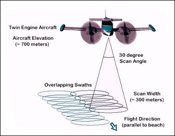
How the LIDAR system works.
The following points outline some of the benefits and results obtained from LIDAR data:
- Modern systems are able to record five returns per pulse. This allows large datasets to be gathered.
- Has the ability to distinguish various layers, from bare earth to canopy and levels in between.
- Can measure reflectance percentages that allow identification of broad land use.
- Can collect terrain data of steep slopes, shadowed areas and other inaccessible locations.
- Scanning can occur day or night.
Once the flight is completed, the raw data is processed through computer software to produce geographically accurate longitude, latitude and elevation (x,y,z) positions for all the data points. These points can then be used to create Digital Elevation Model (DEM) data. The image below shows intensity data created from a LIDAR scan.
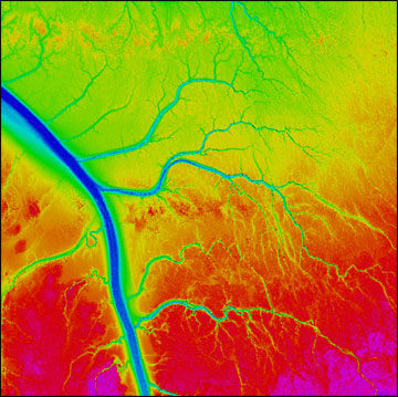 LIDAR intensity data, Willapa Bay, Washington.