Image Overlays
A fairly recent technology is Virtual Reality Modeling Language VRML. It is simply a 3D interchange format designed with the World Wide Web in mind.
VRML files are usually called worlds. The world files are text based and contain vertice and edge information for 3D polygons. They can also store data about colour, opacity and image-mapped textures. Further collective development of VRML is undertaken by the Web3D Consortium.
The media clip below shows a VRML view of Mount St Helens created by 3DEM from USGS DEM data and a Landsat 7 photograph. The VRML viewer shown in the clip was created by GLView and allows real-time exploration of terrain surfaces.
View larger version of media clip.
The example above illustrates the projection of a photograph onto a 3D polygon environment. With the use of high resolution images and camera projection, it is possible to create very realistic environments.
Large parts of the globe have now been photographed via aerial methods. The School of Conservation Sciences, Bournemouth University, kindly provided the following high resolution photograph of the Bournemouth and Poole area. The first figure below shows the area that the photograph covers and the second media clip shows the photograph viewed in GetMapping. The media clip shows the process of zooming in and the high level of detail.
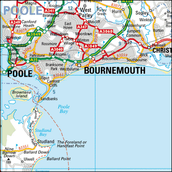
Bournemouth and Poole area covered by photograph.